
This tour has 8 nodes/spots in all. To view each of the spot, please hover the mouse over the thumbnails and click on it in the bottom middle of the tour window. If you wish to view this spot on the tour map, click on the Map button on the left bottom corner.
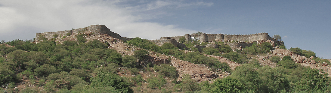
The Hill Fort – Chandragadh
This Hill Fort is located in Atmakur Mandal nearer to Jurala Project. The picturesque Hill fort is located on the banks of river Krishna. This Fort was built during Peshwas of Maratha kingdom and belongs to Chandrasena Jilledar.
The fort was used as a Granary and constructed very strongly. Taxes collected from people and necessary staff and some maratha army was posted at the fort. From this Granary, Food grains were be transferred to Peshwas when ever required by them. There are 5 small Ponds on this hill fort . These Ponds are always filled with water. This Hill fort is visible from a distance of a few kilometers.
Chandragad is a Village in Mahbubnagar District of Telangana State, India. It is located 50 KM towards west from District head quarters Mahabubnagar and 170 KM from the State capital Hyderabad. Chandragad is surrounded by Chinnachintakunta Mandal towards East, Makthal Mandal towards west, Dhanwada Mandal towards North, Atmakur Mandal towards South.
Gadwal, Narayanpet, Mahbubnagar, Wanaparthy are the near by Cities to Chandragad.Chandraghad is about 2 km from the main road between Jurala and Atmakur.
How to reach:
Nearby Railway station is Gadwal and about 25 Km.